Featured Route
Why Adventure Riding in Albania
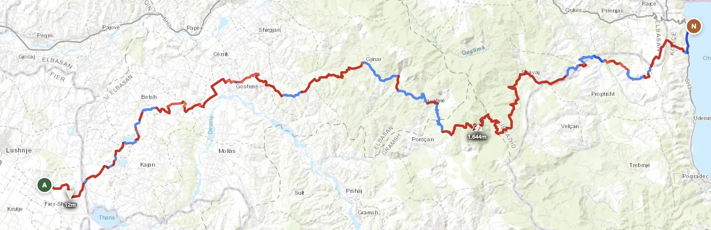
Albania sits at a geographic crossroads — the Albanian Alps meet the Balkans meet the Mediterranean. The result is a landscape of deep mountain valleys, vast high plateaus and southern coastal ranges, all connected by gravel tracks that see almost no traffic. The infrastructure is minimal, which is the whole point: you're riding raw mountain roads without the tourist layers of other Balkan countries.
The reward for this remoteness is solitude and a sense of authentic mountain riding. You won't see another motorcycle for hours. Villages appear out of nowhere — stone houses, local guesthouses, livestock on the roads — and the landscape shifts from Alpine to Mediterranean as you descend. Albania demands respect — roads are rough, logistics are sparse, and weather can shift fast — but riders who accept those conditions find one of Europe's last real wilderness ADV experiences.
The Regions
The northern frontier. Bajram Curri is the gateway to the Accursed Mountains, a maze of high passes, stone villages and shepherd tracks. Snow blocks passes until late April. The most dramatic and least developed region.
Rolling plateau country around Lezhe and Dibra. Less dramatic than the Alps but deeper in offroad character. Broader valleys, longer visibility and a better fuel infrastructure than the far north. The spine of most multi-day routes.
Lower elevations south of Berat toward Gjirokaster. Where mountains meet the Mediterranean influence. Roads improve but still heavily gravel, and the landscape shifts to drier, rockier terrain with Peloponnese-like character.
When to Ride
Albania has a long riding season by Balkan standards. The coast and south are warm from March, with May to October being reliably good across the whole country. The Albanian Alps in the north are the exception — Bajram Curri and the high passes can hold snow until late April and close again in November. July and August bring heat in the lower valleys but the highlands stay comfortable. Winter in the north is wet, cold and the unpaved tracks turn to mud — avoid December through February for anything above 800m.
How to Fit It Into Your Route
- Albania north-to-south loop. Enter via the Albanian Alps from Montenegro, cross the central highlands, and exit south toward Greece — a 3–4 day immersion in the rawest Balkan terrain.
- Montenegro → Albania → North Macedonia connector. Cross from the Accursed Mountains south through the central plateaus and link to the North Macedonia border routes, tying three countries together.
- Greece → Albania cultural crossing. Ride north from the Greek border through southern ranges and the Central Highlands toward the Mediterranean Adriatic coast at Durrës.
Practical
Fuel stations are common in cities and along main roads but sparse in the northern highlands. Fill up in Bajram Curri before heading into the Alps — the next reliable station can be 80–100 km away on mountain tracks.
Albania uses the Lek (ALL), not euros. Card payments are unreliable outside Tirana and Durrës — carry cash Lek for rural guesthouses, fuel stations and restaurants.
Land borders with Montenegro, Kosovo, North Macedonia, Greece and the Adriatic Sea. Schengen rules apply with Montenegro and Greece; non-EU borders with Kosovo and North Macedonia require passport control.
Small guesthouses and family-run bujtina exist throughout the highlands. Tirana is the natural hub with full amenities. Wild camping in the mountains is widely tolerated.
Coverage drops sharply in northern valleys and mountain sections. Download offline maps before heading into the mountains — signage is minimal on many tracks.
Coastal and southern areas reach 25–35°C in July–August. Highlands stay cooler (12–20°C). Winter in the north is cold and wet; April snows are common above 1,200m.
Plan an offroad route in Albania
Set your start and end — GoraAdv finds the most offroad line between them. Adjust, calculate, export GPX.
Open the Planner →