Featured Route
Why Adventure Riding in Australia
Australia is a continent the size of mainland USA with the population of Texas — the most extreme road-density-per-km² gap in the developed world. The result is a network of dirt the like of which doesn't exist anywhere else: thousands of kilometres of unmaintained station tracks, fire trails, mining roads, government 4WD routes, and the proper bucket-list crossings (Birdsville, Strzelecki, Tanami, Canning Stock Route). Three big terrain zones dominate — the southern alpine country (Victorian Alps, Snowys, Tasmania), the rural temperate east coast, and the Outback that fills the centre and north.
Australia rewards riders who plan logistics and respect the country. Distances are real (300–500 km between roadhouses out west), heat is real (45°C summer days in the centre), and the wildlife is the actual #1 hazard — kangaroos at dawn and dusk are the leading cause of motorcycle off-runs in the rural south-east. Get the season right, carry enough fuel and water for the gaps, fit an inReach for the Outback, and you get a country that nothing in the northern hemisphere prepares you for.
The Zones
Australia's alpine country — pubs in old gold-rush valleys, alpine cattlemen's huts at 1,500 m, dirt tracks following the Great Dividing Range. Wonnangatta, Bogong, Dargo, Mt Hotham. Best Mar–May (autumn) and Sep–Nov (spring). Snow closes the high country Jun–Aug.
The classic Australian ADV pilgrimage. 1,000+ km dirt crossings between roadhouses, ochre desert, salt lakes, gibber plains. Carry 12+ litres of water per day and enough fuel for 500 km gaps. Best May–Sep — winter is the only safe window. Summer is genuinely dangerous.
The far north — Cape York Peninsula's Old Telegraph Track is a legendary ride through croc-country creek crossings and dense rainforest. Best May–Oct (dry season). Wet season (Nov–Apr) closes the cape entirely — every crossing becomes uncrossable.
When to Ride
Australia inverts the European calendar but adds a twist: the south and the north have opposite seasons. South-east (Vic Alps, Snowys, the featured Adelaide–Canberra route): autumn (Mar–May) and spring (Sep–Nov) are the windows — summer is dangerously hot, winter brings alpine snow. The Outback (NT, WA, central): May–Sep only, winter is the only safe time to be there. Cape York and tropical north: May–Oct dry season exclusively; the wet season turns every crossing impassable. Plan around the region you're targeting, not the country as a whole.
Regions to Plan Around
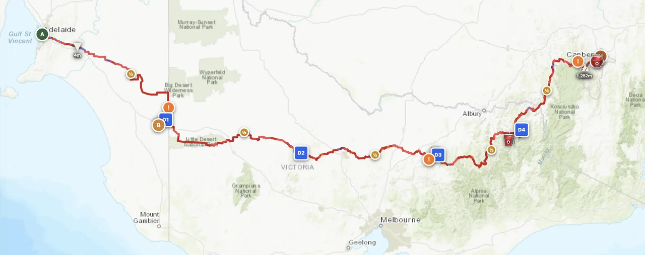
- → South-east traverse — The featured Adelaide–Canberra route or its variants (Melbourne–Sydney via the High Country). 5–7 days through three deserts, the Grampians and the Alps. Best Mar–May or Sep–Nov.
- → Outback crossing — The classic Tanami, Birdsville, Oodnadatta or Strzelecki Track. 7–14 day commitment with 500 km roadhouse gaps. May–Sep only. Carry water, fuel, sat messenger and a working bike.
- → Tasmania loop — Smaller scale, denser network, alpine forest tracks and the West Coast wilderness. 5–7 day island loop. Ferry from Melbourne. Best Nov–Mar (their summer).
Practical
Roadhouse network is dense in the south-east, sparse in the Outback (300–500 km gaps are normal on Tanami, Canning, Birdsville). Long-range tank or jerry cans essential out west. Always confirm next station has fuel before committing to a stretch — Outback roadhouses do close.
Australian dollar (AUD). Cards accepted everywhere except some remote roadhouses (carry cash). ATMs in every town of any size. Fuel prices spike in remote areas — budget AUD 2.50–3.50/L for the Outback vs ~2.00 in cities.
eVisitor or ETA visa required for most western passports — apply online, processed in hours. Bringing your own bike requires a Carnet de Passages (expensive, complex). Most international riders rent or buy locally. Insurance is standard CTP — included in registration.
Free camping is widespread — every town has free or cheap rest areas, every National Park has bush camping with permit. Roadhouses have basic donga rooms. Pubs in country towns rent rooms cheaply. Wild camping in the Outback is allowed almost anywhere; ask at stations if on private land.
Highway corridors covered. Outback interior, Cape York and the High Country = nothing for hundreds of km. A satellite messenger (Garmin inReach or similar) is non-negotiable for any Outback route. UHF CB is the local culture — channel 40 is the trucking/comms standard.
Kangaroos at dawn and dusk are the leading motorcycle hazard in the rural south-east — never ride those hours unless you have to. In the tropical north, watch for crocodiles at all water crossings. Snake bite is rare but real in summer; carry a compression bandage.
Plan a south-east traverse
Set your start in Adelaide and end in Canberra — GoraAdv routes you across three deserts, the Grampians and the Alps, automatically.
Open the Planner →