Featured Route
Why Adventure Riding in Laos
Laos is the only landlocked country in South-East Asia and arguably the most underrated for ADV riding on the continent. Land area is mostly mountains — the Annamite range runs the entire 1,100 km Vietnam border, the Luang Prabang range fills the north, and the Bolaven Plateau dominates the south. Roads are sparse outside the Vientiane–Luang Prabang corridor, paved highways are rare beyond Routes 13 and 9, and the dirt-track network through the highlands has more in common with northern Thailand or upper Myanmar than with Vietnam's denser road grid. Population is just 7.5 million in a country the size of Britain.
For ADV riders, Laos is the South-East Asia trip you take when Thailand has too many tourists and Vietnam has too much traffic. Tracks are quiet, the people are warm and curious about motorcycle travelers, fuel is everywhere in town centres, and the highland pace is genuinely slow. Two real caveats: the dry season is short (Nov–Mar) and outside it the highland tracks are dangerous; and unexploded ordnance from the Vietnam War remains a documented hazard in Xieng Khouang, Houaphanh and parts of the southern provinces — stick to marked roads and tracks, never venture cross-country off-piste, and respect any "UXO" warning signage.
The Zones
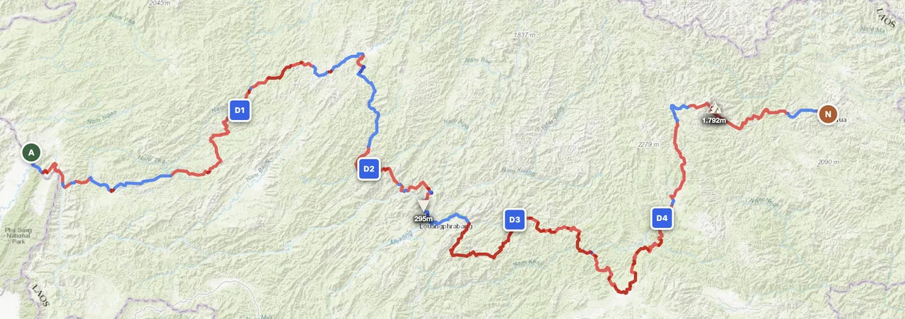
The classic northern Lao ADV zone. Hill-tribe villages (Akha, Hmong, Khmu), 1,000–2,000 m mountain ranges, dirt track networks linking minority communities. Luang Prabang is the natural fly-in base. Best Nov–Feb dry-cool window; Mar–May is dry but increasingly hot.
The mysterious megalithic Plain of Jars at 1,100 m altitude, the Phou Khao Khouay plateau, and the Vietnam War history of this region. Stick rigorously to marked roads — Xieng Khouang is one of the most heavily UXO-contaminated provinces in the world. Best Nov–Mar.
The southern volcanic plateau — coffee plantations, dramatic waterfalls (Tad Fane, Tad Yuang), French-colonial trade tracks, ethnic minority villages. Easier riding than the north, with the famous Bolaven loop accessible to less-experienced riders. Best Nov–Apr.
When to Ride
Laos has a sharp dry/wet season split. November through February is ideal — cool nights in the highlands (sub-10°C above 1,500 m), clear days, dry tracks. March and April are dry but increasingly hot (35°C+ in lowlands) and the slash-and-burn agricultural haze can reduce visibility to a few hundred metres. May through September is the wet season; mountain dirt tracks become impassable mud, fords flood, and landslides close highland routes regularly. October is the cleanup shoulder — paths reopen, temperatures drop. February is exceptional for the central highlands.
Regions to Plan Around
- →Luang Prabang & northern loop — Luang Prabang as fly-in base, ride through Phongsaly, Luang Namtha and back. 5–10 day northern highland tour. Best Nov–Feb.
- →Plain of Jars + Vietnam border — Phonsavan as base, explore the central highlands and the Vietnam-border crossing at Nam Xoi. 4–6 days. Strict on-marked-routes only due to UXO. Best Nov–Mar.
- →Bolaven Plateau loop — Pakse as base, classic 3–4 day waterfall-and-coffee loop through the southern plateau. Easiest of the three regions. Best Nov–Apr.
Practical
Stations in towns of any size; sparse in the highlands — 80–150 km gaps between stations off the main routes. Rural fuel is sometimes sold from village shops in litre bottles. Carry extra for any northern or central highland crossing. Quality is variable in remote stations.
Lao kip (LAK) — high inflation, prone to short-term volatility. Cash dominant outside Vientiane and Luang Prabang. USD and Thai baht widely accepted. Cards work in cities, less in rural areas. ATMs in major towns.
Visa on arrival for most western passport holders (~USD 30–50, 30 days). Vehicle import (TIP) at land borders — straightforward from Thailand (Friendship Bridges) and Vietnam (Lao Bao, Nam Xoi); cumbersome from China. Insurance via local broker at the border.
Guesthouses everywhere in towns (USD 15–30/night). In remote villages, ask the village headman — homestays are common and welcoming. Wild camping is possible but coordinate with locals. Major towns have proper hotels.
Coverage in towns and along main routes (Routes 13, 9). Mountain interior, Vietnam-border zones and the deeper Bolaven Plateau have multi-100 km gaps. Satellite messenger essential for solo highland riding.
Laos was the most heavily bombed country per capita in history (Vietnam War era). Unexploded ordnance remains a real hazard in Xieng Khouang, Houaphanh, Savannakhet and Salavan provinces. Stick rigorously to marked roads and tracks; never venture cross-country off-piste; obey all UXO warning signs. The MAG and UXO Lao programs provide local maps if planning extended highland rides.
Plan a Lao highland traverse
Set your start in Luang Prabang or Vientiane and let GoraAdv route you through the Annamite mountain track network, automatically.
Open the Planner →