Featured Route
Why Adventure Riding in New Zealand
New Zealand packs more terrain into 268,000 km² than any country its size has any right to. The North Island is volcanic — active stratovolcanoes (Ruapehu, Ngauruhoe), thermal areas, dense temperate rainforest, dairy country and the long sweeping East Cape. The South Island is alpine — the Southern Alps run the spine, glacier-fed rivers, lakes the colour of opal, and a backcountry gravel network that includes the Otago and Central Otago rail trails plus the Molesworth Station crossings. Two narrow ferries on Cook Strait connect them.
For ADV riders, NZ is dirt-density paradise. Almost every region has a parallel gravel network alongside the paved highways — what's a State Highway 1 corridor in the centre is a 4WD track in the high country. The country is small enough to tour comprehensively in 2–3 weeks, the people are exceptional to motorcycle travelers, fuel is everywhere, and the only real catches are the ferry-bookings logistics and the simple fact that the riding is so good you'll find yourself extending the trip to fit it all in.
The Zones
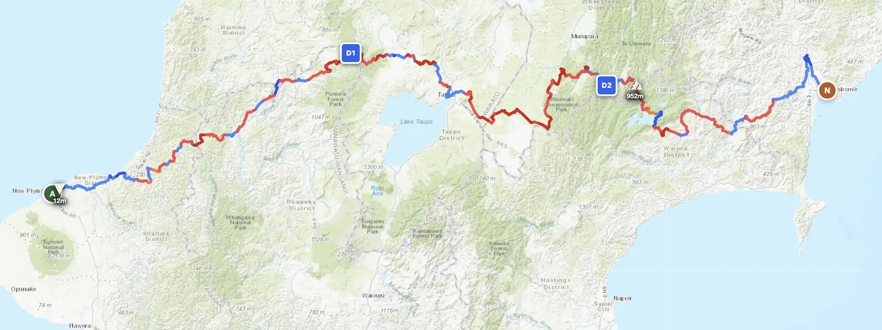
The featured-route zone. Active volcanoes (Ruapehu 2,797 m), thermal areas, dense temperate rainforest, Māori-managed wilderness in Te Urewera. Best Nov–Apr. Snow on the volcanoes in winter (Jun–Sep) closes the high routes.
The South's spine. Glacier-fed rivers, the Aoraki/Mt Cook range (3,724 m), Lakes Tekapo, Wakatipu, Wanaka. Dense gravel network on both sides of the Alps. Best Dec–Mar; September–October is shoulder with good chance of weather windows.
The South Island's drier eastern flank — Central Otago's wine and gravel country, the Otago Central Rail Trail (off-bike but instructive), and the famous Molesworth Station crossing in Marlborough. Good shoulder-season choice; the South's eastern flank stays drier than the west coast.
When to Ride
November through April is the southern hemisphere summer — the standard NZ window. Days are long (Dec–Jan: 16+ hours of light), days are warm (20–28°C in lowlands), and the high country is clear of snow. May through August is winter: Southern Alps are snowed in, North Island volcanic plateau gets snow at altitude, and west-coast rainfall is heavy. September–October is the shoulder — the South starts opening up, the North is rideable but can be wet. The Southern Alps weather is famously fast-changing — pack proper layers regardless of season.
Regions to Plan Around
- →North Island traverse — The featured New Plymouth–Gisborne route, or Auckland–Wellington with the volcanic plateau. 5–10 days. Best Nov–Apr.
- →South Island full circuit — Picton ferry south through Marlborough, down the West Coast, around Fiordland, up the East. 14–21 day full circuit. Bookend with the Cook Strait ferry. Best Dec–Mar.
- →Both islands combo — 21+ day national tour. Auckland → Wellington → ferry → Picton → Bluff → ferry back. The classic NZ ADV pilgrimage. Best Dec–Mar.
Practical
Stations are dense across both islands; even small towns have fuel. The longest gaps are on the West Coast (South) and around Te Urewera (North) — 100–150 km between stations is the worst case. Premium 95 octane is widely available; 91 standard everywhere.
New Zealand dollar (NZD). Cards accepted everywhere — even at remote rural petrol stations. ATMs in every town. Tipping is not customary. NZ is comparatively expensive (fuel ~NZD 2.50–3.00/L, accommodation NZD 100+ for basic).
NZeTA visa-waiver for most western passports — apply online, processed in days. Bringing your own bike requires a Carnet (rare for visitors); most international riders rent or join an organised tour. Quarantine inspection is strict — clean your gear before arrival.
DOC (Department of Conservation) huts and camping sites are the rider's best friend — cheap, well-maintained, in spectacular locations. Holiday parks in towns. Wild camping is restricted but well-signed; respect local regulations. Backpackers (hostels) are common and cheap.
Coverage is good on highways and in towns. Te Urewera, the West Coast (South) and the South Island's interior have coverage gaps. Satellite messenger recommended for remote South Island routes; less critical for North Island where you're rarely more than 30 km from a town.
Summer 18–28°C in lowlands, cooler in the South. The Southern Alps are alpine — sub-zero overnight at altitude even in summer. Pack layers regardless of forecast. The west coast (South) gets enormous rainfall (5,000+ mm/year in places); decent rain gear is mandatory.
Plan a North Island traverse
Set your start at New Plymouth and end at Gisborne — GoraAdv routes you across the volcanic plateau and Te Urewera, automatically.
Open the Planner →