Featured Route
Why Adventure Riding in Mexico
Mexico is the most underrated motorcycle destination in North America. Two parallel mountain spines — the Sierra Madre Occidental running 1,500 km from Sonora to Jalisco, and the Sierra Madre Oriental further east — frame a high central plateau, with the Baja peninsula extending another 1,200 km of desert into the Pacific. Between the spines you have terrain that includes Chihuahuan grasslands, pine forests above 2,500 m, volcanic highlands, jungle in the south, and 9,000 km of coast. The road network has a quirk that's gold for ADV riders: paved highways are sparse outside the central corridor, so an extensive web of secondary dirt roads, ranch tracks (terracerías), and old logging and mining routes is still in active everyday use.
For the rider, Mexico offers something rare in the modern world: vast areas where you don't see another motorcycle for hundreds of kilometres. The Sierra's mining and ranching towns hold cultural depth that you ride into rather than past. Fuel is cheap, food is excellent, and Mexicans treat motorcycle travelers with a hospitality that feels lost elsewhere. The riding rewards patience and good planning — pick your zone, ride during the day, fill up before every Sierra section, and an entire continent of adventure opens up that most North American riders never see.
The Zones
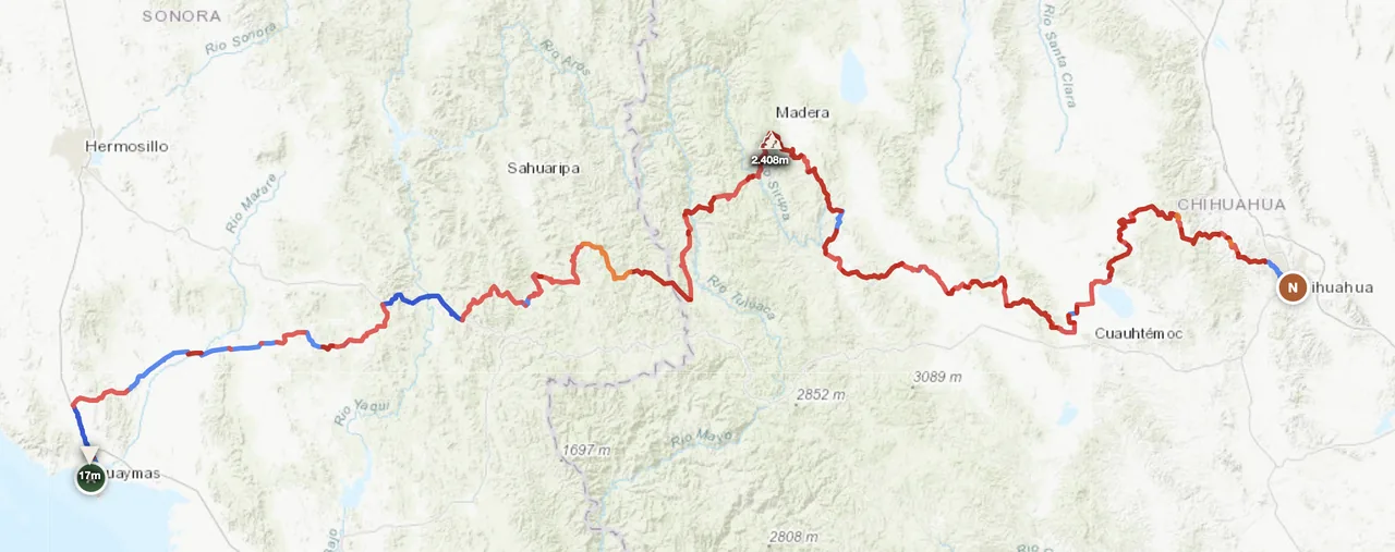
The big one. Pine forests at 2,000–2,800 m, ranch tracks running parallel to Highway 16 for 800+ km, and a reliable network of small towns (Madera, Yécora, Creel) for fuel and food. Best Nov–Apr — winter is the dry season here, summer brings violent thunderstorms that turn dirt to slick clay within minutes.
Desert peninsula between the Pacific and the Sea of Cortez. Highway 1 is paved end-to-end but the parallel dirt tracks (Mex 1 paralelo, the Baja 1000 race line) deliver everything you came for: empty arroyos, missions, fish tacos in beach palapas. Water is the real planning constraint — cache 6 L per day in summer.
Mexico City sits at 2,240 m, ringed by Popocatépetl, Iztaccíhuatl, and Pico de Orizaba (5,636 m — North America's third-highest peak). Forest tracks loop around Toluca, Puebla, Veracruz at 2,500–3,500 m. Good year-round if you ride morning to early afternoon and avoid wet-season thunderstorms after 14:00.
When to Ride
Mexico's offroad season is the inverse of the European one: November through April is dry season across the whole country, with cool clear days in the Sierra and warm but bearable days in Baja. May is the shoulder month — Baja gets uncomfortably hot, the Sierras are still dry. June through September is rainy season, and "rainy" means short violent afternoon thunderstorms that turn dirt tracks to slick clay and cause flash floods in arroyos. October is the cleanup month — paths reopen, temperatures drop. February is exceptional: cold mornings in the Sierra (sub-zero possible at altitude), but bone-dry tracks and the air is at its clearest.
Regions to Plan Around
- → Sonora corridor — Border crossings at Nogales or Sásabe drop you straight into the Sierra Madre Occidental. The Sonora-Chihuahua spine is a 5–7 day window of nearly unbroken offroad. Best Dec–Mar when nights are cold but days are dry and clear.
- → Baja peninsula — Ride from Tijuana or San Diego southbound, ferry from La Paz to Mazatlán if you want to continue inland. The peninsula works as a 7–14 day standalone trip. Nov–Apr only — past May the desert gets dangerously hot.
- → Central volcanoes loop — Mexico City as base, loop through Puebla, the Sierra de Pachuca, and back via Toluca. 3–5 day weekend ride at 2,000–3,500 m. Year-round if you ride mornings only during the wet season.
Practical
Premium 92-octane is widely available in towns. Sierra crossings can have 100–200 km gaps between stations — carry 8–10 L extra fuel for the Sonora-Chihuahua and Baja interior runs. Stations in remote towns sometimes run out for a day or two; ask before committing to a stretch.
Mexican peso (MXN). Cards work in cities and major towns. Cash only in rural areas, ranches, and most fuel stops outside the highway corridors. Carry small denominations for tolls, food stalls, and the occasional informal road fee.
FMM tourist permit required for any visit beyond the immediate border zone (free if entering by air, around USD 30 by land). For trips into mainland Mexico you also need a Temporary Vehicle Import permit. Mexican motorcycle insurance is mandatory and cheap — buy it at the border crossing or online before you ride in.
Wide range: rancho-style guest houses, small-town hotels, beach palapas in Baja, and proper hotels in cities. Wild camping is fine in remote areas with permission from the landowner — Mexicans are usually generous if you ask politely. Avoid camping near major highway corridors at night.
Coverage is strong on highways and around towns, but the Sierra Madre interior and central Baja have hundreds of km without any signal. A satellite messenger (Garmin inReach or similar) is essential for solo Sierra crossings — there are stretches where you're a full day's ride from the nearest help.
Coastal humidity hits 30–35°C in dry-season afternoons. Sierra altitude drops nights to 0°C in winter and can stay cool all day. Pack layers — a January morning at 2,500 m feels nothing like the same afternoon at sea level. Wet-season thunderstorms are the real hazard, not heat.
Plan a Sierra Madre crossing
Set your start in Sonora and end in Chihuahua — GoraAdv routes you through 800 km of ranch tracks and pine forest at 2,000+ m automatically.
Open the Planner →