Featured Route
- →90% offroad — almost no asphalt across the entire length of the country. Possible because Moldova's quiet rural road network is overwhelmingly dirt and the route avoids the M14 paved spine entirely.
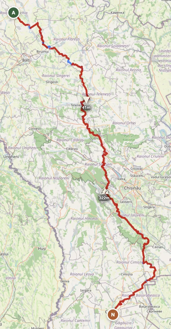
- →4,633 m of cumulative climbing on a country with a 322 m peak — the rolling Codru hills in the centre add up across hundreds of small ridges between vineyards and farm tracks.
- →Bypasses Chișinău to the east — keeps the route entirely rural through wine country and the Codru forest belt, ending in autonomous Gagauzia in the south.
Country Overview
Moldova is one of Europe's smallest and least-known countries (33,846 km²). The terrain is gently rolling — the highest point is just 430 m at Bălănești Hill — and the country splits between agricultural plains and the central Codru forest belt. For motorcycles it's a connector country between Romania (south and west) and Ukraine (east), with the unusual draw of the world's largest underground wine cellars at Mileștii Mici (a UNESCO record-holder) and Cricova.
Forest tracks in Moldova are managed by Moldsilva (the state forestry agency) and motor vehicle access outside marked roads is restricted in protected zones. Practically, the country's appeal is in its quiet rural roads, wine-country dirt connectors, and the very low cost of travel — Moldova is the cheapest country in Europe by most measures. ADV-wise, expect gentle rather than dramatic terrain, but a riding experience that genuinely slows you down.
The Zones
The largest forest in Moldova, mostly oak and beech, with a network of quiet paved roads and a few permitted forestry tracks. Best Apr–Oct.
The southern wine corridor — paved roads connect dozens of vineyards and the giant underground cellar complexes (Mileștii Mici holds the world record). Stay sober riding; tasting-then-back-on-the-bike is not advisable.
The river valley along the eastern edge. Note: the Transnistria region is a de facto separate territory — has its own border controls and is best avoided by motorbike unless you specifically plan for it.
When to Ride
Moldova has a temperate continental climate — warm summers, cold winters. May through September is ideal: dry, warm, comfortable. April and October are shoulders. Winter (Nov–Mar) is cold (down to −10°C) with occasional snow; rideable but uncomfortable. Summer thunderstorms are short and violent.
Regions to Plan Around
- →Wine country day loop — Chișinău base, ride through Cricova and Mileștii Mici with the option to pair with a tasting day off the bike. 1–2 days.
- →Codru forest & Orheiul Vechi — Central Moldova loop including the Codru forest and the Orheiul Vechi monastic complex carved into limestone cliffs. 2–3 days.
- →Romania connector — Use Moldova as the eastern leg of a Romanian Carpathians trip. Cross-border at Sculeni (north) or Albița (south).
Practical
Stations dense around towns; sparse in rural interior — carry extra fuel for longer rural rides. Currency is Moldovan leu (MDL); cards work in Chișinău, cash dominant elsewhere. Visa-free for most western passport holders. Vehicle import (TIP) at Romania and Ukraine borders. Cheap accommodation throughout — pensiunes and guesthouses €15–30/night. Cellular coverage is good. Continental climate; pack rain gear. Avoid Transnistria unless specifically prepared for the additional border.
Plan a Moldova ride
Set your start in Chișinău and explore the wine country or use Moldova as the eastern Romanian connector — GoraAdv routes you on the road network, automatically.
Open the Planner →