Featured Route
Why Adventure Riding in Canada
Canada is the second-largest country on earth and the most population-sparse big country anywhere — almost all of its 41 million people live within 200 km of the US border, leaving an interior larger than Western Europe with road density approaching zero. The result is a network of forestry tracks, mining roads, gravel highways and old logging routes connecting tiny mountain towns through some of the most spectacular terrain on the planet. The country splits roughly into the BC interior + Rockies, the prairie provinces, the Canadian Shield (Ontario/Quebec lake country), the Maritimes, and the territorial north (Yukon, NWT, Nunavut) where the Dempster and Dalton Highways are the legendary destinations.
For the rider, Canada means time and distance. The featured BC route covers five ranges in five days; a true cross-country attempt is 8,000+ km. Fuel and accommodation density is good in the south, sparse in the north and interior. People are warm and the riding culture is strong (BC and Alberta have huge ADV scenes). The catches: short season (Jun–Sep window for most of the country), bears and other wildlife to respect, and the simple fact that the country is so big you'll want a fly-in regional approach rather than trying to cover it all in one go.
The Zones
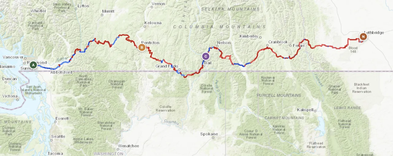
The featured-route zone. Mountain crossings between BC and Alberta, dense forest service road network, ferry-crossings of long lakes, the Trans-Canada gravel parallels. Best Jul–Sep when high passes are clear of snow. Vancouver and Calgary are the natural fly-in points.
The bucket-list zone. The Dempster Highway runs 740 km of gravel from Dawson City to Inuvik above the Arctic Circle. Top of the World Highway crosses into Alaska. Best Jul–Aug only — the season is brutal short. Bears, fuel gaps, isolation are all real.
Smaller scale, denser network, French-Canadian culture in Quebec. The Cabot Trail in Cape Breton is famous for paved scenery; the dirt parallels through the Gaspé peninsula and Algonquin Park are quieter and more interesting for ADV. Best Jun–Sep. Black flies in early summer are a real consideration.
When to Ride
Canada has a short, intense riding season. June through September is the south's window — high passes clear, glacier-fed creeks at manageable levels, days long enough to ride 12+ hours. May and October are shoulders: snow can still close higher BC routes in May, and Alberta gets its first hard frosts in October. North of 60° (Yukon, NWT) the window shrinks to July–August only — the rest of the year is genuinely dangerous to ride. The Maritimes and southern Ontario have a slightly longer window (May–Oct) but black-fly clouds in early June are a serious factor.
Regions to Plan Around
- →BC interior crossing — Vancouver to Calgary via the featured route. 5–7 days through five mountain ranges. Fly into YVR, fly out of YYC, no logistics overhead. Best Jul–Sep.
- →Dempster Highway — Dawson City to Inuvik above the Arctic Circle. 1,500 km return on gravel. 5–7 days. Best Jul–Aug only. Ferry crossings of the Mackenzie and Peel rivers; carry extra everything.
- →Maritimes loop — Halifax base, loop through Cape Breton and the Gaspé peninsula. 7–10 day low-altitude tour with French-Canadian culture and dramatic Atlantic coast. Best Jul–Sep after the black flies.
Practical
Excellent station network in the south, sparse in the territorial north. The Dempster has 200+ km gaps between Eagle Plains and Inuvik. BC interior is fine — gravel highway corridors all have small-town fuel within 100 km. Carry extra for any north-of-60° riding.
Canadian dollar (CAD). Cards accepted everywhere except some remote indigenous community stores. ATMs in every town. USD widely accepted near the border at unfavourable rates. Tipping culture is North American (15–20%).
eTA visa-waiver for most western passports, US passport-only entry. Bringing your own bike requires a Carnet for visitors over 6 months; most international riders rent or buy locally. US border crossings are quick if your paperwork is clean — declare every modification to the bike.
Crown land camping is free across most of BC, AB, YT — pitch a tent anywhere outside parks with no permit. Provincial parks have established sites at modest cost. Small-town motels common in the south. Hot springs and lodges in BC interior are a notable bonus.
Highway corridors and towns are well-covered. BC interior backroads, the Yukon and the Maritimes interior all have multi-100 km signal gaps. Satellite messenger (Garmin inReach or similar) is standard kit for any north-of-60° or BC backcountry riding.
Black bears throughout, grizzlies in BC and the territorial north. Carry bear spray in BC backcountry — it works. Hang food at camp. Moose collisions are the number-one motorcycle hazard at dawn/dusk in the prairie provinces and the north — avoid those hours where possible.
Plan a BC interior crossing
Set your start in Vancouver and end in Calgary — GoraAdv routes you through five mountain ranges on dirt and gravel, automatically.
Open the Planner →