Featured Route
Why Adventure Riding in Paraguay
Paraguay is South America's quiet middle. Landlocked, low-altitude, and split by the Río Paraguay into two completely different countries: the eastern half (where almost everyone lives) is rolling subtropical hills with Atlantic Forest fragments, dense rural settlement, and a rich agricultural dirt-road network. The western half (the Chaco) is one of the largest contiguous wildernesses in the Americas — flat, hot, dry, sparsely populated, and crossed by a single proper highway (the Trans-Chaco). For ADV riders that split is a gift: two utterly different terrains in the same country, both rideable, neither crowded.
Paraguay rewards riders who like to disappear. There are almost no foreign tourists outside Asunción and the Iguazú border, almost no road traffic outside the few highways, and a Guaraní-Spanish bilingual culture that's distinct from anywhere else in the region. Fuel is cheap. Pace of life is slow. The riding doesn't try to impress — it just delivers hundreds of kilometres of quiet rural dirt with green hills, river crossings, and the occasional Mennonite colony in the Chaco. Underrated, under-ridden, completely yours.
The Zones
The riding heart of the country. Subtropical hills (200–500 m), Atlantic Forest fragments, dense network of rural caminos vecinales, river crossings, small Mennonite and Guaraní settlements. 88%+ offroad routes are normal here. Best Apr–Sep when humidity drops.
Flat, dry, vast — one of the largest contiguous wildernesses in the Americas. The Trans-Chaco highway is the spine; everything else is dirt tracks across cattle estancias and Mennonite colonies (Loma Plata, Filadelfia). Adventurous and lonely. Carry water and fuel for 300+ km gaps.
The southern strip along the Argentine border holds the UNESCO Jesuit mission ruins (Trinidad, Jesús), warmer climate, and dirt-track networks through Yerba Mate plantations. Quieter than the east-traverse corridor, perfect for a slower 3–4 day southern loop.
When to Ride
Paraguay's offroad season is the southern hemisphere winter — April through September. Days are clear, temperatures drop into the bearable 20–28°C range, and the rural dirt is dry. Summer (Dec–Feb) is brutal: 35–40°C with 90% humidity, plus violent thunderstorms that turn the eastern hills' dirt into red-clay slop. The Chaco is even worse in summer — dangerous heat. June–August is exceptional: cool nights, dry days, and the Atlantic Forest in its driest state. Note that the Chaco floods unpredictably in shoulder months — check local conditions before committing to a Trans-Chaco crossing in March or October.
Regions to Plan Around
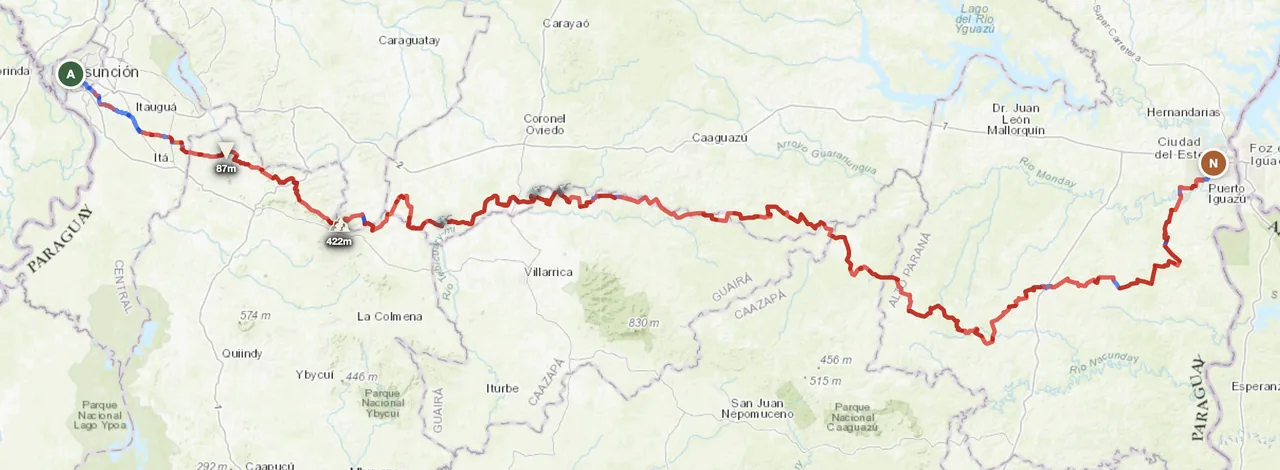
- → Asunción → Iguazú traverse — The featured east-west route. 3-day ride with the Iguazú falls as the natural endpoint. Best Apr–Sep. Pairs perfectly with crossing into Brazil or Argentina afterward.
- → Trans-Chaco west crossing — Asunción to the Bolivian border via the Mennonite colonies. 4–6 day adventure through the Chaco wilderness. Heat and isolation are the real challenges. Carry extra fuel and water for 300+ km gaps.
- → Jesuit missions southern loop — Encarnación as base, loop through the UNESCO mission ruins and the Yerba Mate plantations. 3–4 day southern circuit at low altitude in the rural southeast.
Practical
Stations are common in eastern Paraguay (every town); sparse in the Chaco — 200–300 km gaps between Mennonite-colony stations on the Trans-Chaco. Diesel is everywhere; gasoline 95 octane is widely available but quality varies in remote stations. Carry extra fuel for the western crossings.
Paraguayan guaraní (PYG). Cash dominant outside Asunción and Ciudad del Este. ATMs reliable in cities, less so in small towns. USD is widely accepted in the Iguazú border zone. Bring small denominations for rural fuel and food stops.
Visa-free for most western passport holders for 90 days. Vehicle import (TIP) at land borders is straightforward. Border crossings into Brazil (Ciudad del Este → Foz do Iguaçu) and Argentina (Encarnación → Posadas) are heavily used and well-marked. Insurance via local broker.
Small-town posadas are cheap and welcoming throughout the east. Estancias often offer rider-friendly camping with secure parking. Wild camping is fine in remote areas with permission. Mennonite colonies in the Chaco have basic but excellent guesthouses (Loma Plata, Filadelfia).
Coverage is good on highways and in the eastern half. The Chaco interior is mostly without signal — there are stretches of 200+ km without coverage. A satellite messenger (Garmin inReach or similar) is essential for any Chaco crossing.
Subtropical with extreme summers (Dec–Feb): 35–40°C and 90% humidity in the east, dangerously hot in the Chaco. Winter (Jun–Aug) is mild — 18–25°C days, cool nights. Always pack rain gear; thunderstorms are violent year-round but most common in summer.
Plan a Paraguay traverse
Set your start in Asunción and end at Ciudad del Este — GoraAdv routes you through 88% offroad on rural dirt to the Iguazú border, automatically.
Open the Planner →