Featured Route
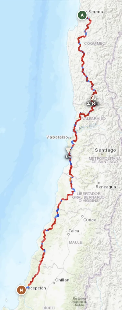
- →86 fords on a 1,400 km route — the most ford-dense GoraAdv route after Bolivia, crossing dozens of Andean glacier-melt creeks coming off the Cordillera
- →Crosses Chile's wine corridor — Aconcagua, Maipo, Colchagua and Maule valleys — on the dirt connectors parallel to the paved Ruta 5 (Pan-American)
- →Bypasses Santiago via the Cordillera foothills — the cleanest way to ride south through central Chile without touching the megacity sprawl
Why Adventure Riding in Chile
Chile is the most geographically extreme country on earth. 4,300 km long but on average just 175 km wide, it spans every climate zone outside the tropics — Atacama desert in the far north (the driest place on the planet), Mediterranean wine valleys around Santiago, dense temperate rainforest in the lake district, the Carretera Austral cutting through Patagonian fjords, and Tierra del Fuego at the bottom. The Andes form the eastern wall the entire way down, with Aconcagua (6,961 m) and dozens of other 6,000+ m peaks within sight of every central road.
For ADV riders, Chile delivers the most varied 4,000 km of riding on earth. Distances are real (Arica to Punta Arenas is roughly Stockholm to Cairo), so most riders pick a section. Fuel and accommodation are the most reliable in South America, English-speaking ratio is the highest, and the road network is dense in the central valleys. Caveats: Patagonia is summer-only, the Carretera Austral has multiple ferry crossings to plan around, and the Atacama needs water-carrying like the Outback. Pick your latitude band, ride it well.
The Zones
The featured-route zone. Mediterranean climate, dense dirt-road network through wine valleys, the Aconcagua massif visible to the east. Santiago is the obvious base; ride north or south on parallel dirt to escape the Pan-American. Year-round rideable; best Sep–May.
The driest desert on earth, ringed by 6,000+ m volcanoes. Dirt tracks through ochre canyons, salt flats (Salar de Atacama), the Bolivia border at Paso Jama (4,200 m), and the Argentina border at Paso Sico. Best Apr–Nov; summer (Dec–Feb) is the "Bolivian winter" rainy season at altitude.
The legendary southern gravel highway through the Patagonian fjords. Multiple ferry crossings, dense temperate rainforest, glacier-fed rivers, the Aysén region wilderness. Best Dec–Mar; the rest of the year is wet and cold, ferries reduce or stop. The bucket-list Chilean ride.
When to Ride
Chile's seasons depend dramatically on which latitude. The above grid is for the central spine (La Serena → Concepción) — austral summer Oct–Apr is ideal. Atacama in the north inverts this slightly: Apr–Nov dry, Dec–Feb is "winter altiplano" with afternoon thunderstorms above 3,000 m. Patagonia and the Carretera Austral are even more seasonal: Dec–Mar only, the rest of the year ferries reduce, weather closes routes, and the wet cold becomes genuinely dangerous. Plan around your target zone, not the country as a whole.
Regions to Plan Around
- →Central spine — The featured La Serena → Talcahuano route. 7 days through wine country and Cordillera foothills. Best Sep–May.
- →Atacama loop — San Pedro de Atacama as base, ride the high-altitude tracks to Salar de Tara, the Argentina border at Paso Jama, and the Bolivian salar de Uyuni day trip. 5–7 day high-desert tour. Best Apr–Nov.
- →Carretera Austral — Puerto Montt south to Villa O'Higgins on the legendary 1,240 km gravel highway. 10–14 day Patagonian commitment with multiple ferries. Best Dec–Mar.
Practical
Excellent station network in central Chile — every town has fuel. Atacama has 200+ km gaps; Carretera Austral has 100–150 km gaps with occasional outages. Copec and Shell are the dominant brands. Premium 95 widely available; 93 standard.
Chilean peso (CLP). Cards accepted everywhere except remote roadhouses on the Carretera Austral or Atacama interior. ATMs reliable in all towns. Chile is one of the more expensive South American countries — budget accordingly.
Visa-free for most western passport holders for 90 days. Vehicle import (TIP) at land borders straightforward. Andean crossings to Argentina (Paso Jama, Pehuenche, Cardenal Samoré) and Bolivia (Hito Cajón) all open seasonally; check pass status in winter. SAG agricultural inspection is strict — declare all food.
Hostales and cabañas everywhere; small-town hotels in the centre. National parks have established camping. Carretera Austral has rider-friendly campgrounds at Cochrane, Tortel and beyond. Wild camping is fine in remote areas with respect; ask at estancias for permission on private land.
Coverage strong in the centre and along Pan-American Ruta 5. Atacama interior, Carretera Austral and Patagonia have multi-100 km gaps. Satellite messenger essential for any solo Atacama or Austral riding — there are stretches where breakdown without one is multi-day.
Climate varies dramatically with latitude. Central Chile Mediterranean (Sep–May 18–28°C). Atacama days hot/nights freezing year-round. Patagonia summer 8–18°C with violent winds; winter sub-zero and wet. Pack for the latitude band you're targeting.
Plan a central Chilean traverse
Set your start at La Serena and end in Concepción — GoraAdv routes you down the central Cordillera foothills past Santiago to the Bío-Bío coast, automatically.
Open the Planner →