Featured Route
Why Adventure Riding in Peru
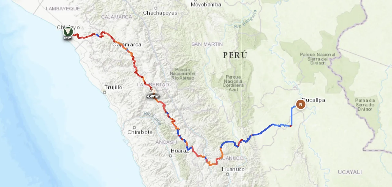
Peru is built around a single geographic fact: the Andes run north-to-south through the country, splitting it into three radically different regions. The Costa is the narrow Pacific coastal strip — desert, dunes, the Pan-American Highway and the Nazca Lines. The Sierra is the high Andean spine — Cordillera Blanca with 6,000 m+ peaks, Cordillera Huayhuash, the Sacred Valley around Cusco, and the altiplano around Lake Titicaca. The Selva is the eastern Amazon basin — cloud forest dropping into rainforest, Manu and Tambopata, the cities of Iquitos and Pucallpa accessible only by river or plane. ADV-wise: each region delivers a totally different ride, and the trans-Andean traverses connect them.
Peru rewards riders who are willing to commit to altitude. The Sierra means days at 3,500–4,500 m where the air is thin, the weather is intense and the people are wonderful. The Cordillera Blanca dirt routes are some of the most spectacular high-altitude riding on earth. Caveats: altitude needs proper acclimatization, the Selva descent is wet year-round (afternoon thunderstorms even in dry season), and fuel/parts in the Sierra are sparse. Plan May–September for Sierra, year-round for Costa, and October–April for the (slightly less) wet Selva.
The Zones
The defining zone. 5,000–6,000 m peaks with extensive dirt-track networks at 3,500–4,500 m baseline. Cordillera Blanca is the alpine heart; the Sacred Valley around Cusco is the cultural heart; the southern altiplano connects to Bolivia. Best May–Sep dry season.
Narrow coastal desert, 2,400 km long. Pan-American Highway is the spine; parallel tracks through dunes, fishing villages, and pre-Inca archaeological sites (Chan Chan, Caral, Nazca Lines). Hot and dry year-round; fog ("garúa") in Lima winter (Jun–Sep).
The eastern lowlands — cloud forest dropping into Amazon rainforest. Track networks are limited (rivers are the main transport) but the Andean-descent roads are spectacular: Manu road, Cusco–Puerto Maldonado, the route to Iquitos. Hot, humid, wet year-round; Apr–Oct is the drier window.
When to Ride
Peru's offroad calendar is dominated by the Sierra dry season — May through September. Days are clear, fords cross-able, dirt is dry. October and April are shoulders. November–March is the wet season: altiplano dirt becomes deep clay, fords flood, mountain landslides close routes. The Costa is dry year-round (genuinely arid) but Lima coastal winter (Jun–Sep) brings thick fog. The Selva is wet year-round; Apr–Oct is drier. June–August is exceptional for trans-Andean traverses combining all three regions.
Regions to Plan Around
- →Cordillera Blanca loop — Huaraz as base, ride the dirt circuit around Huascarán (6,768 m). 5–7 days through the most dramatic Andean glacier scenery. Best Jun–Sep. Acclimatize 2–3 days at altitude first.
- →Sacred Valley & Cusco region — Cusco as base (3,400 m), explore the dirt connectors between Inca sites (Pisac, Ollantaytambo, Maras). 4–6 day cultural-mountain combo. Best May–Oct.
- →Trans-Andean Costa-to-Selva — The featured route concept. Pacific coast across the Sierra and down into the Amazon. 5–7 days through three biomes. Best May–Sep.
Practical
Stations dense on the Costa (Pan-American), sparse in the Sierra and Selva. Plan 200–300 km tank ranges for high-Andean stretches. Fuel quality varies in remote areas; carry filter or a clean cloth. 90 octane (corriente) most common; 95 (extra) in cities only.
Peruvian sol (PEN). Cards accepted in cities and tourist towns (Cusco, Lima, Arequipa). Cash only in rural Sierra and Selva. ATMs reliable in major towns. USD widely accepted at touristy spots and for international vehicle import fees.
Visa-free for most western passport holders for 90 days (extendable). Vehicle import (TIP) at land borders, valid for the same period. Land borders with Ecuador (Tumbes), Bolivia (Desaguadero, Yunguyo), Chile (Tacna), Brazil (Iñapari) all open.
Hostales and hospedajes in towns; basic accommodations in altiplano villages. Cusco/Arequipa/Lima have everything. Wild camping is possible in the Sierra above villages — cold (sub-zero overnight at altitude). Arrange permission with local communities in indigenous areas.
Coverage strong on the Costa Pan-American and around major cities. Sierra interior has multi-100 km gaps. Selva is patchy — towns covered, between them nothing. A satellite messenger (Garmin inReach or similar) is essential for any Cordillera or Selva-descent solo riding.
The Sierra means days at 3,500–4,500 m. Acute mountain sickness is common; acclimatize 2–3 days at moderate altitude (Cusco 3,400 m or Huaraz 3,050 m) before pushing higher passes. Carry coca leaves, acetazolamide, and hydration. Cold compounds the altitude effect — pack proper layers.
Plan a trans-Andean traverse
Set your start on the Pacific coast and end in the Amazon basin — GoraAdv routes you across all three Peruvian regions, automatically.
Open the Planner →