Featured Route
Why Adventure Riding in Colombia
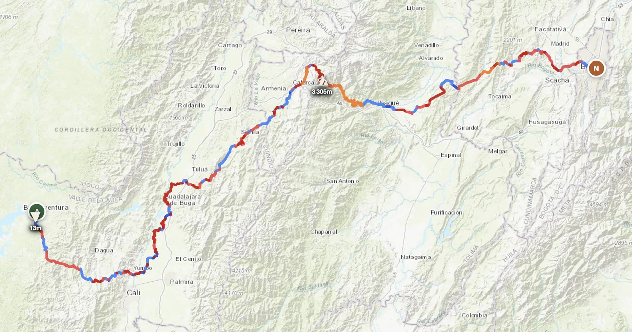
Colombia is South America's most geographically dense country. The northern end of the Andes splits into three parallel cordilleras (Western, Central, Eastern) running south-to-north for 1,500 km, with the Cauca and Magdalena valleys between them. The Caribbean coast in the north has its own range — the Sierra Nevada de Santa Marta, the world's highest coastal mountain range (5,775 m). The Pacific coast is dense rainforest. The eastern half of the country drops into the Llanos and the Amazon. In a single 700 km route you can ride sea-level coast, three mountain ranges, two valleys and a high altiplano.
For ADV riders, Colombia is the most rewarding South American country to ride per kilometre. Distances are short by SA standards, the road network is dense, the Coffee Triangle and Boyacá highlands have extensive dirt connectors between paved highways, and the riding culture is strong — Colombians ride motorcycles in huge numbers and treat foreign riders well. Caveats: the Pacific coast is genuinely wet (5,000+ mm/year of rain), some rural areas have past or present security considerations (research before committing), and the altitude swings will catch unprepared riders. Plan around dry-season windows and stick to the well-traveled Andean corridor for the first trip.
The Zones
The defining geography. Three parallel ranges with the Cauca and Magdalena valleys between them. Passes routinely above 3,000 m, dirt-track networks dense in the highlands, dramatic descents into the inter-Andean valleys. The featured route crosses all three in one go.
The most rideable concentration of dirt in the country. Rolling coffee farms, fincas, palm-shaded valleys, dense network of caminos that connect tiny pueblos. UNESCO-listed cultural landscape. Best Dec–Feb dry season; year-round rideable with afternoon rain.
The northern coast and the world's highest coastal range — Pico Cristóbal Colón (5,775 m) rises directly out of the Caribbean. Hot, humid coast with palm-track networks; the Sierra has dramatic high routes. Best Dec–Apr dry season. Hot and humid year-round at sea level.
When to Ride
Colombia has two distinct dry seasons in the Andean region — December through February and July through August. Both are ideal for offroad in the cordilleras and Coffee Triangle. April–May and October–November are the two wet seasons (Andean: bimodal rainfall pattern), and the Pacific coast is wet year-round (Buenaventura averages 5,000+ mm/year). The Caribbean coast (Cartagena, Santa Marta) follows the Atlantic-tropical pattern — Dec–Apr dry, May–Nov rainy. Plan your route around both regional patterns if combining the Andes with the coast.
Regions to Plan Around
- →Pacific → Andes traverse — The featured Buenaventura → Bogotá route. 4 days, three cordilleras. Best Dec–Feb or Jul–Aug.
- →Coffee Triangle loop — Pereira or Manizales as base, 5–7 day loop through the cafetero region's dirt connectors. Year-round rideable with afternoon-rain caveats.
- →Caribbean & Sierra Nevada — Santa Marta or Cartagena as base, ride into the Sierra Nevada from sea level to 3,500+ m altitude. 4–6 day combo of beach and high mountain. Best Dec–Apr.
Practical
Stations dense in cities and along highway corridors. Mountain crossings can have 80–120 km gaps; carry extra for the Pacific-side Western Cordillera. Gasoline 87 octane (corriente) and 91 (extra) widely available; no diesel for bikes (gasoline only).
Colombian peso (COP). Cards accepted in cities and most highway-corridor towns. Cash only in rural areas and small mountain pueblos. ATMs in every town of any size. USD accepted at touristy places (Cartagena) at unfavourable rates.
Visa-free for most western passport holders for 90 days. Vehicle import via TIP at land borders (with Ecuador, Venezuela, Brazil, Panama via Darien-bypass shipping). Insurance via local SOAT (mandatory, cheap, buy at border).
Hostels everywhere in cities and tourist towns. Fincas in the Coffee Triangle accept overnight guests with bike parking. Wild camping is possible in remote areas but coordinate with local communities. Stay in established accommodations near major highways at night.
Coverage strong on highways and around cities. Mountain interior, Pacific coast and the Llanos can have multi-100 km gaps. A satellite messenger (Garmin inReach or similar) is standard kit for any high-cordillera or Pacific-coast solo riding.
Climate is altitude-driven. Bogotá altiplano (2,640 m) is "eternal spring" 8–20°C year-round. Cauca Valley (1,000 m) hot 25–30°C. Pacific coast hot-humid. Sierra Nevada altitude swings dramatic — pack layers covering everything from 5°C alpine to 35°C coast.
Plan a Pacific-to-Andes traverse
Set your start at Buenaventura and end in Bogotá — GoraAdv routes you across three Andean cordilleras and into the capital, automatically.
Open the Planner →