Featured Route
Why Adventure Riding in Venezuela
Venezuela is a country of extraordinary diversity packed into a relatively small footprint. The Caribbean coast in the north gives way to the Andean páramos along the Colombian border in the west; the central Llanos plains span the entire middle; the Guiana Shield rises in the south as the Gran Sabana — a tepui-dotted highland that includes Angel Falls and Roraima. For ADV riders the appeal is the variety: in a single trip you can ride sea-level Caribbean dirt, climb 4,000 m+ Andean passes, cross 1,000 km of empty savannah, and end at the base of the world's highest waterfall.
Caveats are real and should be planned for. Venezuela has been through a difficult decade — fuel, parts and accommodation infrastructure are not what they were 20 years ago. Riders should plan around carrying extra fuel, USD cash for transactions, and a flexible itinerary. Border crossings (especially with Colombia and Brazil) are slow. The reward, for those who plan well, is a country that gives the most varied 1,000 km of riding in South America with almost zero foreign tourists.
The Zones
South America's vast cattle plains — flat, hot, savanna grass, dirt roads connecting cattle ranches and small towns. 1,000+ km of horizon-line riding. Best Dec–Apr (dry); the wet season (May–Nov) floods the Llanos and many tracks become rivers.
The Guiana Shield highlands — flat-topped tepuis (Roraima, Auyán-tepui, Kukenán) rising 1,000 m+ from grassland, waterfall country, dirt tracks through Pemón indigenous territory. Best Nov–Apr. The Brazilian-border road (Troncal 10) is one of South America's great rides.
The eastern end of the Andes — Pico Bolívar (4,978 m), Mérida cable car, páramo grasslands and the trans-Andean back roads. Cooler, higher, dramatic. Drive carefully — fog, narrow roads, occasional landslides. Best Dec–Mar dry season.
When to Ride
Venezuela's seasons are pronounced — December through April is dry, May through October is wet (called invierno locally even though it's in the warm season). The Llanos in the wet season is largely unrideable; many dirt roads turn into shallow lakes and the 30-ford featured route becomes one continuous river crossing. The Gran Sabana stays drier than the Llanos but afternoon thunderstorms are intense year-round. The Mérida Andes can be ridden any month but rainy-season fog reduces visibility on the high passes to single-digit metres.
Regions to Plan Around
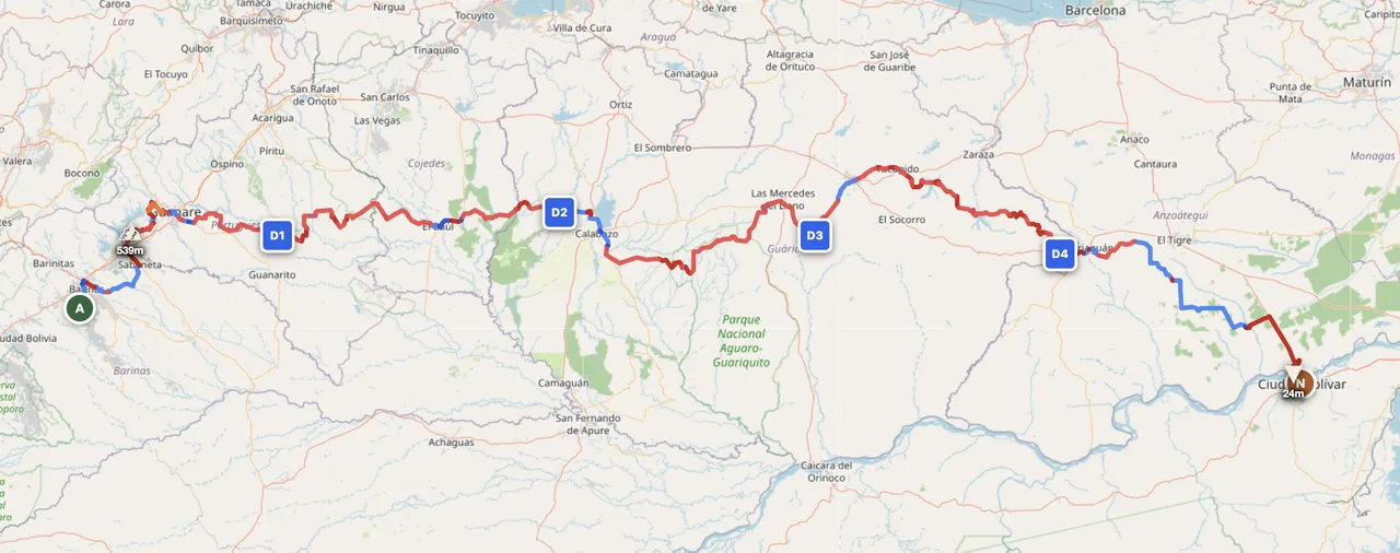
- →Caribbean coast → Llanos → Orinoco — The featured route. 5 days from sea level to Ciudad Bolívar via the central plains. Best Dec–Apr.
- →Gran Sabana & Brazil border — Ciudad Bolívar south on Troncal 10 to Santa Elena de Uairén and the Brazilian border. 3–5 day extension; tepuis, waterfalls, Pemón villages. Best Nov–Apr.
- →Mérida Andes loop — The western Andean range, base in Mérida city. 4–7 day high-altitude tour past the country's highest peaks and páramo grasslands. Best Dec–Mar.
Practical
Subsidised but availability varies — fuel can be in short supply in regions, with long queues common. Carry extra fuel for any Llanos or Gran Sabana stretch. Border-zone stations charge international prices. Bring jerry cans.
Bolívar (VES) is the local currency but is highly inflationary. USD cash is widely accepted and often preferred for any larger transaction (fuel, accommodation, repairs). Bring small US bills. Card use is unreliable outside major cities; assume cash-only for trip planning.
Visa requirements vary by nationality — most western EU passports are visa-free for tourist stays; US passports need a tourist visa in advance. Vehicle import via TIP at land border. Border crossings (Colombia at Cúcuta, Brazil at Santa Elena) are slow — allow a full day.
Posadas (small B&Bs) in towns; ranches in the Llanos sometimes accept guests with permission. Wild camping is possible in remote areas but coordinate with local communities. Avoid camping near major highway corridors at night. Major cities: stay in established hotels with secure parking.
Coverage on highways and around cities; sparse in the Llanos and almost nothing in the Gran Sabana interior. A satellite messenger (Garmin inReach or similar) is essential for any Llanos crossing or Gran Sabana ride — distances between settlements are real.
Hot year-round in lowlands (28–34°C). Llanos in dry season is dry-heat; wet season adds humidity. Mérida Andes are cool to cold (sub-zero overnight at high passes). Coastal humidity is high. Pack layers if combining the highlands with the lowlands in a single trip.
Plan a Venezuela traverse
Set your start in Caracas or Valencia and end in Ciudad Bolívar — GoraAdv routes you across the Llanos to the Orinoco, automatically.
Open the Planner →