Featured Route
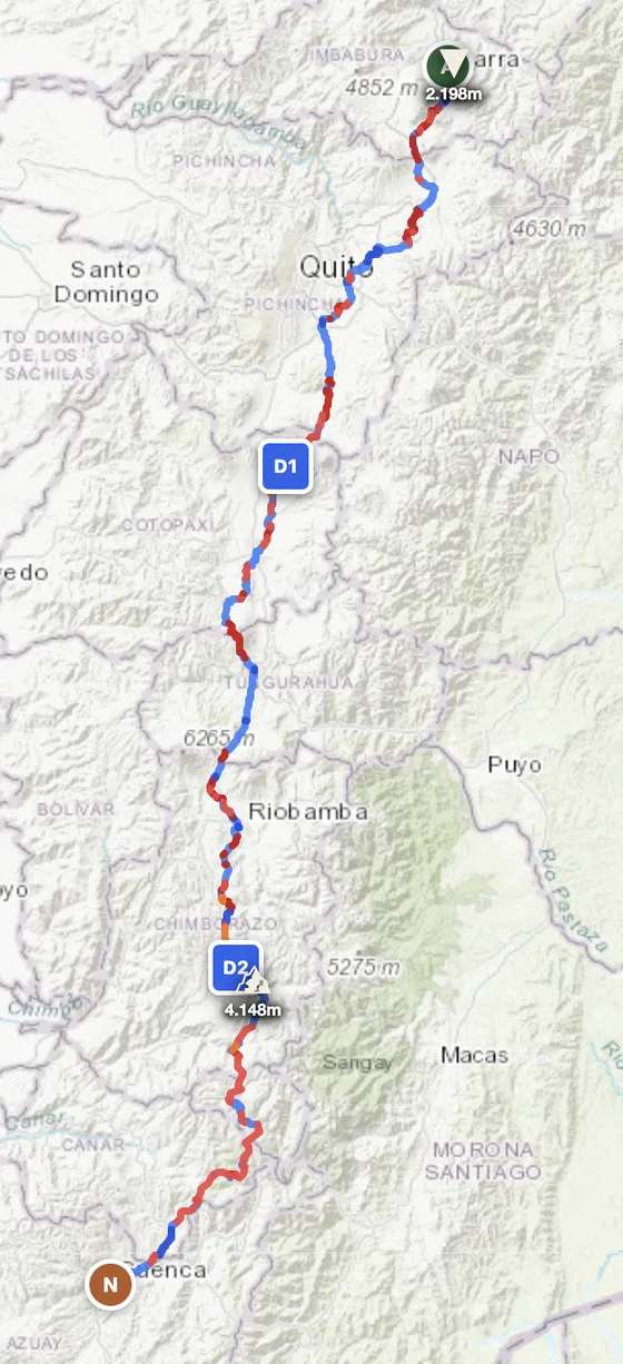
- →15,128 m of climbing across 641 km — Ecuador's compressed Andean spine packs more vertical per kilometre than almost anywhere on the planet, with daily passes between 3,500 m and 4,148 m.
- →Crosses the equator at 0° latitude north of Quito, then runs the full Avenue of the Volcanoes — Cotopaxi (5,897 m), Chimborazo (6,263 m), Tungurahua and Sangay all visible from the route.
- →Mixed surface: páramo dirt and gravel between volcanoes, paved valley connectors when the geography forces it. The whole country end-to-end in three manageable days.
Country Overview
Ecuador is South America's smallest Andean country (283,561 km²) and arguably the most geographically intense per kilometre. The country splits into three regions: Costa (Pacific coastal plain with mangroves and dunes), Sierra (the Andean spine with the Avenue of the Volcanoes — Cotopaxi 5,897 m, Chimborazo 6,263 m, the closest point on Earth's surface to the sun), and Oriente (Amazon basin descent into rainforest). The Galápagos archipelago sits 1,000 km offshore but isn't accessible by motorbike.
ADV-wise Ecuador delivers the same three-biome formula as Peru in a much more compact package — you can ride the equator-crossing, Cotopaxi base, and Tena Amazon descent in a single week. Tracks through the páramo grasslands and the Andean dirt-road network are extensive. Caveats: altitude (Sierra is 2,000–4,500 m), afternoon thunderstorms in the Amazon descent, and some rural areas have security considerations near the Colombia border.
The Zones
The Andean spine north-south through the country, framed by snow-capped volcanoes. Cotopaxi and Chimborazo are the headline summits; the dirt-track network through the páramo at 3,500–4,500 m connects highland villages. Best Jun–Sep dry season.
The coastal plain — paved coastal road plus dirt connectors through dry tropical forest, mangroves, and surfing villages. Hot and humid year-round. Best May–Dec.
The Andean descent into the Amazon basin. The road from Quito to Tena and onward to Misahuallí is one of the great descents in South America — 3,000 m drop in 200 km through cloud forest into rainforest. Wet year-round; Apr–Jul drier window.
When to Ride
Ecuador straddles the equator — there's no real summer/winter, just dry/wet patterns that vary by region. Sierra (Andean spine): June through September is dry and ideal, October–May has more afternoon rain. Costa: May to December is the drier window. Oriente (Amazon): wet year-round, Apr–Jul slightly drier. The country is rideable any month if you pick the right region for the time.
Regions to Plan Around
- →Avenue of the Volcanoes — Quito south to Cuenca via the Cotopaxi and Chimborazo bases. 5–7 day Andean classic. Best Jun–Sep.
- →Quito → Tena Amazon descent — One of South America's great descents. 2–3 day cloud-forest-to-jungle ride from Andean altiplano to Amazon basin.
- →Coast loop — Guayaquil base, ride the Pacific coast north through Bahía and Esmeraldas. 4–6 day coastal tour with dirt connectors. Best Jun–Nov.
Practical
Stations dense in Sierra and Costa; sparser in the Oriente. Currency is US Dollar (Ecuador adopted USD in 2000). Cards in cities, cash in rural areas. Visa-free for most western passports (90 days). Vehicle import (TIP) at borders. Hotels and hostels everywhere. Cellular coverage strong in populated zones, Amazon descent has gaps. Sierra altitude — Quito 2,850 m, Cotopaxi base 3,800 m — acclimatize before pushing higher. Sub-zero possible overnight at altitude even in dry season.
Plan an Ecuadorian Andean ride
Set your start in Quito and explore the Avenue of the Volcanoes or descend into the Amazon — GoraAdv routes you on the Andean track network, automatically.
Open the Planner →