Utah · USA
Offroad Motorcycle Routes
in Utah.
Red rock, slickrock, and nine distinct mountain ranges — the most varied offroad riding you can string together in a single state, from 1,200m canyon floors to 3,700m summits.
Bald Mountain Pass · 3,232 m
UTBDR · 1,320 km
Best: May – Oct
5 National Parks
Featured Route
1 Day
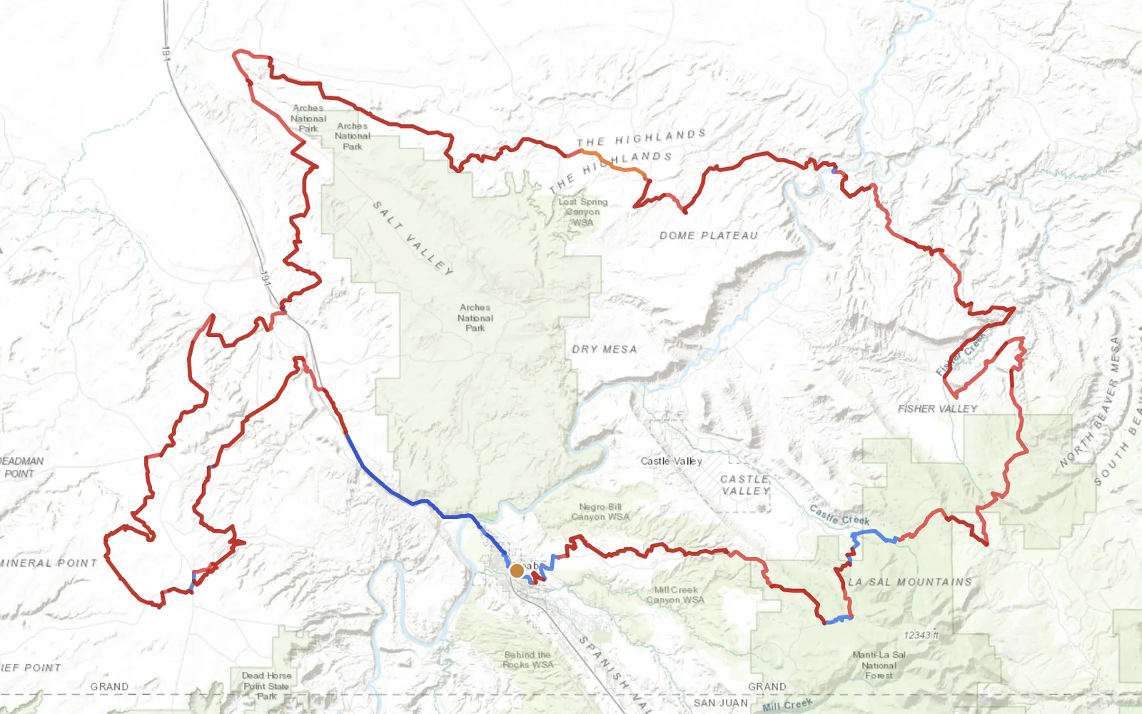
Moab Loop
Moab — Grand County Roundtrip
Start and end in Moab · Arches perimeter → Dome Plateau → La Sal foothills → Castle Valley · a full day of slickrock at nearly 90% dirt
T1 Dirt Track 63%
T2 Gravel Track 25%
T3 Unpaved Road 2%
T5 Highway 10%
- →A Moab-based day loop — leave town on dirt, ride the perimeter of the Arches area, up into Fisher Valley and the Dome Plateau, back through Castle Valley into Moab
- →Nearly 90% dirt with almost no track repetition — six distinct canyons in a 10-hour ride, from red-rock wash floors to the La Sal mountain edge at 2,676 m
- →Best April–May and September–October. July and August slickrock surface temperatures pass 60 °C — uncomfortable for the rider, hard on the tyres
Plan your Utah offroad route →
Why Adventure Riding in Utah
Utah is the state where adventure riders go when they want something that doesn't exist anywhere else on the continent — the slickrock plateau, a single geological formation that crosses four counties, where you can ride for hours on exposed sandstone that feels like riding on a wet chalkboard but with grip. Add to that nine separate mountain ranges, five national parks, and public land that covers two-thirds of the state, and you have the densest variety-per-kilometre of any state in the country.
The UTBDR is the obvious anchor but it's not the whole story. Moab alone has more named jeep trails than most states have named roads. The Tushar Mountains in the south and the Uintas in the north are both underrated — alpine riding above 3,000m that almost nobody talks about because the red rock gets all the photos. If you want variety on a single trip, Utah is the most efficient state in the US.
The Regions
Canyon Country
1,200–2,000 m — southeast Utah
Moab, Canyonlands, Glen Canyon, Capitol Reef. The headline terrain — red rock, slickrock, slot canyons. Rideable March through November with a gap in July and August when surface temperatures on exposed rock pass 60°C. Shade is rare; water is rarer.
The Uintas
2,500–3,700 m — northeast Utah
The only east–west range in the lower 48 states. Long alpine meadows, genuinely high passes, and a dense forest-road network. Opens mid-June, closes with the first big storm in October. The counterweight to Canyon Country if you want altitude and pine.
The Tushars
2,400–3,700 m — central-south Utah
Underrated volcanic range south of Richfield. Three peaks above 3,600m, dense spruce-fir, and a loop network that gets almost no traffic compared to the San Juans next door. Good gravel condition, rideable June through early October.
When to Ride
Jan
Feb
Mar
Apr
May
Jun
Jul
Aug
Sep
Oct
Nov
Dec
Ideal
Possible
Avoid
Utah splits the calendar in half by elevation. The canyon country is rideable April–May and September–October — avoid midsummer when surface temperatures on slickrock make the bike uncomfortable and the rider dangerous. The high country (Uintas, Tushars, La Sals) is exactly inverted: June through September is the window, with the first big storm usually closing the high passes by mid-October. The sweet spot for a trip that touches both is the last week of September — high country still open, canyon country cool enough to ride all day.
Regions to Plan Around
-
→
Moab & the La Sals · Red-rock desert around Moab with the alpine La Sal Mountains stacked directly above. Desert floor is rideable October–May; the La Sal loop opens June–October.
-
→
San Rafael Swell · Central-Utah basin — slickrock, canyons, almost no one. Best April–June and September–November; summer is too hot on exposed rock.
-
→
High Uintas & North Slope · Utah's only true alpine range, 3,000–4,000 m, forested and glacial. Short window: July–September.
Practical
⛽ Fuel
Towns are sparse in the canyon country — Hanksville, Hite, Mexican Hat and Torrey are the main pumps, and some are 150+ km apart on dirt. Tank up any time you pass a station. Most close by 9 pm; 24-hour pumps exist only on the interstate corridors.
💵 Currency
US dollars. Cards work everywhere except the smallest outposts. Carry $50–100 cash for dispersed-camp fees, exact-change fuel pumps at remote stations, and the occasional cash-only taqueria — the food is usually worth it.
🛂 Border
Internal US — no state border formalities. Crossing into the Navajo Nation in southeast Utah is not a border but is a separate jurisdiction; their tribal park entrance fees apply where marked.
🏕 Overnight
Dispersed camping is legal on almost all BLM and Forest Service land — most of the canyon country counts. National park campgrounds near Moab and Torrey fill weeks ahead in season; the BLM land around them does not.
📶 Signal
Worse than people expect. Moab, St George, and the interstate corridors have full coverage; ten minutes into the canyon country you have none. A satellite messenger is standard kit on the UTBDR — it's not optional.
🌡 Temperature
Canyon floors in July regularly hit 40°C, surface temperatures on slickrock higher. High-country passes at 3,200m sit at 15–20°C in the same week. A 25°C difference over 1,500m of climb is normal — pack for both.
Plan a Utah offroad route
Set your start and end anywhere in the state — GoraAdv prefers dirt over pavement and will route you through canyon country, the Uintas, and the passes in between.
Open the Planner →